Orography and Elevations
The orography of the Dominican Republic is composed of mountain ranges, sierras and karstic regions that form a northwest-southeast, irregular chain with constant changes on the surface level. These formations emerged due to geological processes on the island, in which faults and movements in the structural folds played a decisive role. These breaks and movements began in the middle of the Jurassic period, in the Mesozoic Era, approximately 130 million years ago, and were a product of the three foliation lines that gave birth to the Antillean arc.
 Mountain Ranges
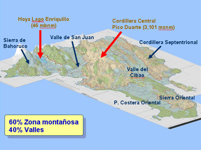
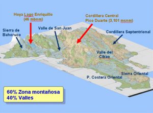
Within the system of cordilleras, there are three mountain masses: the Cordillera Central (Central Range), Cordillera Septentrional (Northern Range) and the Cordillera Oriental (Eastern Range).
- The Cordillera Central is the largest and most important mountain group in the Dominican Republic and covers a large part of its territory. As its name indicates, it is located in the center of the country with a length of 200 km and a width of 100 km. It is the continuation of the “Northern Mass” (Massif Du Nord) found in Haitian territory; its origin dates back to the Cretaceous period. The northern slope, which is a plateau, emerged in the Oligocene period. Igneous and volcanic rocks abound in this mass, in addition to sedimentary and metamorphic rocks. The major peaks of the Antilles are found in this Cordillera: Pico Duarte; 3,175 m, La Pelona, 3,087 m; La Rusilla, 3,038 m and Pico del Yaque, 2,761 m. The main rivers of the country also originate in this system, such as the Yaque del Norte, the Yaque del Sur, the Artibonito, the Yuna, the Nizao, the Ocoa and the Haina.
- The Cordillera Septentrional, second in importance to the Cordillera Central, is located in the northern section of the country, in the northwest-southeast direction and extends from Montecristi to the Gran Estero, close to Nagua. It originated in the Miocene-Oligocene periods of the Cenozoic Era, and is mostly composed of sedimentary rock. Among its most important summits is the Diego de Ocampo peak, with an elevation of 1,229m.
- The third mountain chain is the Cordillera Oriental, located in the eastern part of the country in a west to east direction. It originated in the Cretaceous period of the Mesozoic Era. Its elevations do not rise above 800 m.
Sierras
There are five sierras (or mountain chains) in the Dominican Republic: Sierra de Neiba, Sierra de Bahoruco, Sierra Martín García, Sierra de Yamasá and Sierra de Samaná.
- The Sierra de Neiba is limited to the north as well as to the south by large tectonic faults. Its genesis dates back to the Oligocene period of the Cenozoic Era. The tectonic dynamic from previous periods separated the Sierra from the Sierra Martín García. It has mostly calcareous or saltpeter rocks, creating a karstic relief. The predominant inhabitable regions, with little difference between their areas, are the Wet Forest Low Mountain habitat and the very Wet Forest Low Mountain habitat. It continues in Haitian territory under the names Trou D’Eau and Cadena de Matheaux and
- The Sierra de Bahoruco continues into Haiti, where it is named Massif de la Selle, and has altitudes that reach 2,367 m. Its genesis dates to the Oligocene period of the Cenozoic Era when its first relief was formed. It presents a geomorphology of steep edges and flat valleys: the Aceitillar Basin is in the highest part of the sierra and is of Polje origin (karstic depression caused by lateral and tectonic widening). Sedimentary rocks of caliche origin are most common, creating a karstic relief much like that of the Sierra de Neiba. The predominant habitat is very Wet Forest-Low Mountain.
- The Sierra Martín García, Sierra Llamaza and Sierra Samaná are systems of moderate altitude and in them, the greatest quantity of extractable minerals are found, like gold and silver nugget in Yamasá and marble in Samaná.
Valleys
The valley or lowland relief includes four valleys, the most important of which is the Valle del Cibao, as it is the longest and most fertile, followed by the valleys of San Juan, Bonao and Villa Altagracia. The Hoya de Enriquillo is a depression produced by a caved-in tectonic fault and is noted for its location at 40 m below sea level, the lowest point of the Antilles.
Elevations
The Dominican Republic exhibits variations in its topography that range from depressions of more than 39 m below sea level (mbsl) to approximate altitudes that reach 3,187 m above sea level (masl).
For greater detail, they are grouped in the following ranges: from 39 mbsl to 0 m; from 1 m to 250 masl; from 250 to 500 masl; from 501 to 750 masl; from 750 to 1,000 masl; from 1,000 to 1,500 masl; from 2,000 to 2,500 masl; and from 2,500 to 3,187 masl.
- From 39 mbsl to 0 m. These are the lowest parts of the country, found in the Hoya de Enriquillo, where the Lago Enriquillo, the lake found there, can reach 40 mbsl. It has a total area of 537.24 km2, occupying 1.10% of the total surface area of the country.
- From 1 m to 250 masl. These are the flatlands of the country and are predominant in the southeastern Caribbean and Atlantic coastal plains, the Miches and Sabana de la Mar plains, the Cibao Valley from Montecristi to the mouth of the Yuna and part of the Hoya de Enriquillo. It is the largest elevation category of the country, with a total area of 26,896.44 km2 and 55.52% of the national territory.
- From 250 to 500 masl. This range is composed of slightly inclined areas. The surfaces with these topographic characteristics are dispersed throughout the country. We find them in the northern and southern slopes of the Sierra de Bahoruco, in a large portion of the Cordillera Septentrional, the Promontorio de Cabrera, the San Juan Valley, part of the northern slope of the Cordillera Central and in a large part of the Cordillera Oriental, the southeastern fringe of Santiago and other minor areas, such as the eastern part of the “plena de Azua”. This range occupies a total area of 7,798.17 km2, representing 16.09% of the territory.
- From 501 to 750 masl. These elevations are found in the middle portion of all of the country’s mountainous systems. The range is for the most part represented in the Loma de Cabrera, Partido, Jánico, Sabana Iglesia and the greater part of the eastern slope of the Sierra de Neiba, as well as part of the Cordillera Septentrional. These heights occupy a total area of 4,478.47 km2 of the country, which represents 9.24% of the territory.
- From 750 to 1,000 masl. This elevation range is composed of the areas of pronounced hills in our topography. Generally, the terrain encompassed by this range of elevation are used for seasonal crops. They are mainly found in the middle of the mountains systems of the Cordillera Septentrional, the Sierra de Neyba and the northern slope of the Cordillera Oriental. It boasts 2,736 km2 in area, or 5.64% of the territory.
- From 1,000 – 1,500 masl. These areas are craggy and broken and, in general, the terrain of this topography is shallow. It is principally located in the highest regions of the drainage basins of the country. It covers an area of 3,822.96 Km2, or 7.89% of the land.
- From 1,500 to 2,000 masl. With topographical maps one can appreciate the concentration of these areas on the summits of the mountain systems, principally in the Cordillera Central and its slopes, Sierra de Neyba, Sierra de Bahoruco, Cordillera Oriental and the central region of the Cordillera Septentrional. It covers an area of 1,640.84 km2, which is 3.38% of the territory.
- From 2,000 to 2,500 masl. The great majority of the national parks and scientific reserves are in this range of elevation. It occupies an area of 521.32km2, or 1.07% of the national territory.
- From 2,500 to 3,187 masl. The highest altitudes of the Antilles fall into this range, such as the Pico Duarte, La Pelona, La Rusilla, Pico del Yaque and La Correosa. It occupies an area of 9.80 km2 and represents only 0.02% of the land.
Main Elevations in the Dominican Republic
| Name | Mountain Range | Altitude(Meters) |
| Pico Duarte | Central | 3,175 |
| La Pelona | Central | 3,168 |
| La Rucilla | Central | 3,049 |
| Alto Bandera | Central | 2,842 |
| Loma de la Viuda | Central | 2,801 |
| La Chorreosa | Central | 2,662 |
| Pláticos | Central | 2,585 |
| Pico del Yaque | Central | 2,295 |
| Pico Neiba | Sierra de Neiba | 2,272 |
| Monte Mijo | Central | 2,226 |
| Culo de Maco | Central | 2,189 |
| Pico La Tasajera | Sierra de Neiba | 2,176 |
| Monte Tina | Central | 2,058 |
| Nalga de Maco | Central | 1,960 |
| Pico Loma Fría | Sierra de Martín García | 1,285 |
| Diego de Ocampo | Septentrional | 1,249 |
| Monte Jicoméo Murazo | Septentrional | 1,083 |
| Loma El Mogote | Septentrional | 967 |
| Villa Trina | Septentrional | 967 |
| Loma Quita Espuela | Septentrional | 943 |
| Loma Siete Cabezas | SierradeYamasá | 856 |
| Isabel de Torres | Septentrional | 793 |
| Loma Vieja | Oriental | 736 |
| Pico Los Copeyes | Oriental | 696 |
| Monte Plan de Azúcar | SierradeSamaná | 493 |
Did you know? Karstic regions are composed entirely of saltpeter rocks and feature low elevations that vary between 200 and 300 m. Their primary wealth comes from their subterranean reservoirs and archeological-historical and cultural value in the numerous caverns and national parks that they provide (Los Haitises, Promontorio de Cabrera and Procurrente de Barahona).
Did you know? Dominican rivers lead to four watersheds; three maritime ones (southern watershed or watershed of the Caribbean, Northern watershed or watershed of the Atlantic and the watershed of gulf of Gonave), and one interior watershed (Hoya de Enriquillo).
Did you know? All Dominican rrivers are navigable from the Ozama andl Higuamo -by short distances beginning from the outlet- and the Yan River -navigated by sail boat very close to the Samaná bay.
Did you know? Dominican orography is composed of 60 percent mountainous zones and 40 percent valleys.
Quick Links
Connect With Us!
You can keep updated with our news, events and activities through our digital channels using:
![]()
![]()
![]()
Keep Me Updated!
Keep up with the latest Dominicanaonline events and publications. Fill in your email details on this simple form and we will send you news and updates direct to your mailbox.
Register Now!