Territorial Division
The Dominican Republic has 32 political-administrative divisions (31 provinces and the National District), divided into eight geographic regions. The economic development of these provinces has a close relationship to their geographic locations and the natural resources available. Of the 32 provinces, 17 are coastal, including the National District, and have fishing and tourism as their economic base. Five make up the border with Republic of Haiti along the western border, from San Fernando de Montecristi, in the North, until Pedernales, in the South. The rest of the provinces, considered Mediterranean, use the fertility of their valleys for agricultural development, and the topography and climate of the mountain systems for forest development and eco-tourism activities.
Political map of the Dominican Republic
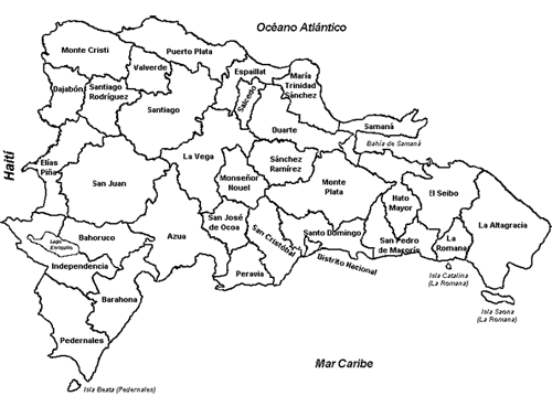
¿Did you know? The provinces with the largest areas are: La Altagracia, Santiago, Azua, La Vega, and San Juan de la Maguana (the largest with 3,664.74 km²). The provinces with the smallest areas are La Romana, Peravia, Valverde, San José de Ocoa, and Salcedo (the smallest with 430 km²).
Sub-regions and provinces
| National District | Santo Domingo |
| Valdesia Region | Peravia, San Cristóbal, Monte Plata and San José de Ocoa |
| East Region | El Seibo, La Altagracia, La Romana, San Pedro de Macorís and Hato Mayor |
| Northeast Region | Duarte, María Trinidad Sánchez, Salcedo and Samaná |
| Cibao Central Region | La Vega, Sánchez Ramírez y Monseñor Nouel |
| Northcentral Region | Espaillat, Puerto Plata and Santiago |
| Northwest Region | Dajabón, Montecristi, Santiago Rodríguez and Valverde |
| Valley Region | Azua, Elías Piña y San Juan |
| Enriquillo Region | Barahona, Independencia and Pedernales |
Provinces, municipalities and capitals
| Provincial code | Province | Municipality | Capital City |
| 01 | DISTRITO NACIONAL | Santo Domingo de Guzmán | Santo Domingo de Guzmán |
| 02 | AZUA | Azua | Azua de Compostela |
| 03 | BAORUCO | Neiba | Neiba |
| 04 | BARAHONA | Barahona | Santa Cruz de Barahona |
| 05 | DAJABÓN | Dajabón | Dajabón |
| 06 | DUARTE | San Francisco de Macorís | San Francisco de Macorís |
| 07 | ELÍAS PIÑA | Comendador | Comendador |
| 08 | EL SEIBO | El Seibo | Santa Cruz del Seibo |
| 09 | ESPAILLAT | Moca | Moca |
| 10 | INDEPENDENCIA | Jimaní | Jimaní |
| 11 | LA ALTAGRACIA | Higüey | Salvaleón de Higüey |
| 12 | LA ROMANA | La Romana | La Romana |
| 13 | LA VEGA | La Vega | Concepción de La Vega |
| 14 | MARÍA TRINIDAD SÁNCHEZ | Nagua | Nagua |
| 15 | MONTECRISTI | Montecristi | San Fernando de Montecristi |
| 16 | PEDERNALES | Pedernales | Pedernales |
| 17 | PERAVIA | Baní | Baní |
| 18 | PUERTO PLATA | Puerto Plata | San Felipe de Puerto Plata |
| 19 | HERMANAS MIRABAL | Salcedo | Salcedo |
| 20 | SAMANÁ | Samaná | Santa Bárbara de Samaná |
| 21 | SAN CRISTÓBAL | San Cristóbal | San Cristóbal |
| 22 | SAN JUAN | San Juan de la Maguana | San Juan de la Maguana |
| 23 | SAN PEDRO DE MACORÍS | San Pedro de Macorís | San Pedro de Macorís |
| 24 | SÁNCHEZ RAMÍREZ | Cotuí | Cotuí |
| 25 | SANTIAGO | Santiago | Santiago de Los Caballeros |
| 26 | SANTIAGO RODRÍGUEZ | San Ignacio de Sabaneta | San Ignacio de Sabaneta |
| 27 | VALVERDE | Mao | Mao |
| 28 | MONSEÑOR NOUEL | Bonao | Bonao |
| 29 | MONTE PLATA | Monte Plata | Monte Plata |
| 30 | HATO MAYOR | Hato Mayor | Hato Mayor del Rey |
| 31 | SAN JOSÉ DE OCOA | San José de Ocoa | San José de Ocoa |
| 32 | SANTO DOMINGO | Santo Domingo Este | Santo Domingo Este |
Source: National Statistics Office (ONE) www.one.gob.do

Quick Links
Connect With Us!
You can keep updated with our news, events and activities through our digital channels using:
![]()
![]()
![]()
Keep Me Updated!
Keep up with the latest Dominicanaonline events and publications. Fill in your email details on this simple form and we will send you news and updates direct to your mailbox.
Register Now!